
A full fledged winter "weather emergency" is underway across northeast Kansas and much of Missouri at this time, with widespread, heavy snow in the Kansas City Metro area and a mixture of ice, sleet and snow in southern Missouri.
Pictures like these are common in the Kansas City area at this hour, where some folks unfortunately didn't heed the warnings of the past few days and ventured out to find themselves stuck in the blinding, heavy snow:

Important winter storm safety tip: if you find yourself stranded in heavy snow, do not exit your vehicle (unless you have to clear the tailpipe of snow or other debris to prevent exhaust fumes from entering the vehicle). It is best to sit it out, especially in a populated area like this one, and wait for help to arrive.
In this next shot, a State Trooper in northeast Kansas is being pulled out of a ditch by a 4x4:

A "State of Emergency" has been declared across the Kansas City metro area, and it was recently announced that KCI Airport is closed until at least 11pm this evening.
The heavy snow that is now falling across the KC Metro area and northern Missouri originated in central Kansas earlier this morning, where 14 inches fell at Hutchinson, 12 inches near El Dorado, and 11 inches at the Wichita airport.
A bit further South, and as we feared the last few days, an ice storm is underway in southern Missouri, along the Arkansas border and into northern Arkansas, as indicated by the red and orange shaded areas on the radar mosaic below:

One-quarter of an inch of glazed ice has been reported at many locations in southern Missouri during the past 2 hours, including the Springfield area (where sleet is now falling). Power outages and very hazardous road conditions can be expected in this region throughout the afternoon, spreading East this evening.
A variety of Winter Weather Advisories and Warnings continue in affect through Friday in association with this storm system:

Continuing on to the South, the situation turns to a severe weather threat along and ahead of the cold front, which is quite well defined on the latest radar mosaic over eastern Texas:

The low levels of the atmosphere are gradually becoming moist and more unstable ahead of the boundary, which will lead a threat of severe thunderstorms this afternoon and evening, primarily within the yellow shaded area on the image below:

Hail to severe limits and possible damaging wind gusts are the primary threats, however a few tornadoes are also possible with the strong storms (particularly those that form out ahead of the main line within the yellow shaded area this afternoon and evening).
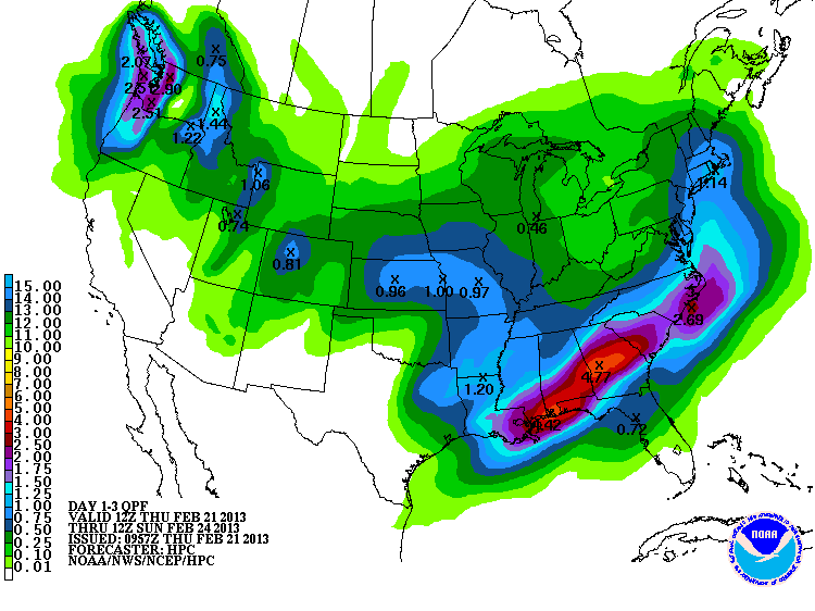
Widespread, torrential rainfall will also be a concern as this system pushes into the lower Mississippi Valley and Deep South through Friday. Much of this area is already experiencing flooding problems from recent heavy rains, and unfortunately, more is on the way:
For more information from 'The Original Weather Blog', including shorter, more frequent posts during rapidly changing weather events, please be sure to follow me on facebook and twitter:


Coming March 2013: The Tornado Chronicles full website!
• Interactive tornado database back to 1950 (earlier years coming soon)
• Interactive radar with live warnings and street-level zoom
• Tornado safety, preparedness and education
• Daily tornado outlooks/threat index
• Photos, videos & more!
No comments:
Post a Comment