
Showers and thunderstorms, some heavy, are ongoing this morning from east-central Texas across Louisiana and into southern Mississippi. This activity will continue to move and/or develop Eastward today, with a threat of strong to locally severe storms.
The latest severe weather outlook with respect to wind and isolated tornadoes for today is shown below. Severe storms are possible anywhere within the brown and yellow shaded areas. Damaging wind gusts are the primary threat, but a few isolated tornadoes cannot be ruled out.

A threat of hail to severe limits extends as far West as east-central Texas, as shown below:

Locally heavy rainfall is also a pronounced threat across much of this same region, which will lead to flash flooding as heavy rain occurs over repeated areas.
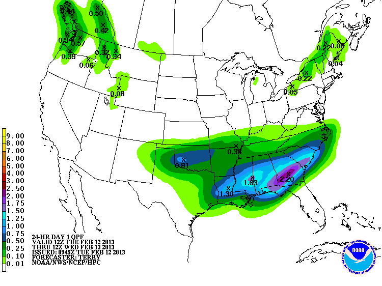
Unfortunately, this risk of heavy rain includes the Hattiesburg, MS, area, where they are still trying to assess the damage from the devastating tornado that took place there on Sunday.
For more information from 'The Original Weather Blog', including shorter, more frequent posts during rapidly changing weather events, please be sure to follow me on facebook and twitter:


Coming March 2013: The Tornado Chronicles full website!
• Interactive tornado database back to 1950 (earlier years coming soon)
• Interactive radar with live warnings and street-level zoom
• Tornado safety, preparedness and education
• Daily tornado outlooks/threat index
• Photos, videos & more!
2 comments:
How did this storm end up turning out? We have had some good weather out West, but I heard it was going to be pretty intense in this area.
sad news..We need your updates on this situation over the coming days.
Post a Comment