An upper-level weather disturbance will move across northern Mexico and southern Texas late tonight and into Wednesday, bringing much needed rain to parts of the Lone Star State.
Right now it appears that the most beneficial rains will fall in a nearly West-East band across the middle Texas coast, into the Houston area and southern Louisiana. Localized amounts in excess of 1.5 inch are possible, as shown in blue and purple on the image below:

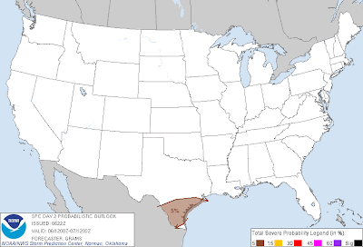
Some of the thunderstorm activity associated with the disturbance may produce hail and/or wind gusts near severe limits in parts of deep south Texas late tonight and into Wednesday, as shown within the brown shaded area on the image below:


Please show your support and follow The Tornado Chronicles on twitter and on facebook for the latest updates on tornadoes and the upcoming website!

Right now it appears that the most beneficial rains will fall in a nearly West-East band across the middle Texas coast, into the Houston area and southern Louisiana. Localized amounts in excess of 1.5 inch are possible, as shown in blue and purple on the image below:

Elsewhere, a general rain of 0.50 inch or less is expected for many locations along and East of I-35.
Some of the thunderstorm activity associated with the disturbance may produce hail and/or wind gusts near severe limits in parts of deep south Texas late tonight and into Wednesday, as shown within the brown shaded area on the image below:

For more information from 'The Original Weather Blog', including shorter, more frequent posts during rapidly changing weather events, please be sure to follow me on facebook and twitter:
Coming March 2013: The Tornado Chronicles full website!
• Interactive tornado database back to 1950 (earlier years coming soon)
• Interactive radar with live warnings and street-level zoom
• Tornado safety, preparedness and education
• Daily tornado outlooks/threat index
• Photos, videos & more!
No comments:
Post a Comment