An upper-level low pressure system is swirling about just to the Northwest of Las Vegas, NV at this hour (as shown on the water vapor satellite image above). This system will dive toward the South/Southeast tonight and Monday, the make a move toward the East across Texas on Tuesday and Wednesday.
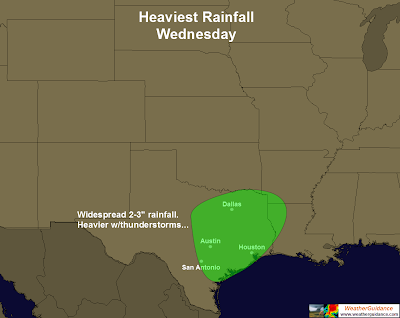
Widespread, heavy rainfall can be expected in association with this system, particularly across central and eastern portions of Texas (especially along and to the East of I-35, including the Austin-San Antonio corridor). Total rainfall amounts for the two day period will average 2-4 inches with locally heavier amounts near 6 inches possible.
Here is how I expect the heavy rainfall threat to pan out for Tuesday:
...and for Wednesday:
As much of this region is currently in a moderate to extreme drought condition, the rainfall will be very welcome, even though some of it may run off quickly during strong to severe thunderstorm activity.
Along with the good will come a threat of the bad, in the form of severe thunderstorm activity. As I've been pointing out for several days now, this situation looks very similar to the one on January 25, 2012, which produced widespread heavy rainfall, damaging wind gusts and at least 1 tornado along the Austin/San Antonio corridor of I-35. That trend has not changed as of this update, and strong to severe thunderstorms will indeed threaten the region on Tuesday and Wednesday:
The severe weather and heavy rainfall threat will shift East/Northeastward into portions of the lower Mississippi Valley region on Thursday.
If you live across the heavy rain and severe weather threat areas outlined for Tuesday and Wednesday of this week, please stay alert. Take the time now to review your severe weather safety and preparedness tips so that you are ready to go if severe weather threatens.
At least some of the threat of severe weather will take place during the nighttime hours. Make sure that you have a way to receive weather warnings when you are asleep at night, and identify your best sheltering option at home, work or school so that you can move there quickly if threatening weather is observed or a warning is issued.
For more information from 'The Original Weather Blog', including shorter, more frequent posts during rapidly changing weather events, please be sure to follow me on facebook and twitter:
If you are in need of highly customized, site specific weather forecasts and/or storm warnings for your business, school or event, be sure visit my professional webpage at WeatherGuidance.com.


2 comments:
i see you expanded the threat area
Thank you for this information. By the way, what's the latest update now in this area?
Weather Philippines
Post a Comment