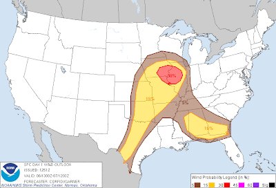
Severe thunderstorms are forecast within the yellow shaded areas on the above image later today and into at least early tonight.
Within each area, large hail, damaging wind gusts and isolated tornadoes will be possible.
There are a couple of areas with an enhanced or elevated risk of a particular type of severe weather. The first is with regard to tornadoes and extends in a corridor from northeastern Oklahoma across eastern Kansas and western Missouri and into southeast Iowa and northern/central Illinois:
The greatest risk is within the brown shaded area on the image, from extreme southeast Iowa into central Illinois. Please keep in mind that this is relative, as any one of the severe storms that form today could produce an isolated tornado. Conditions will be the most favorable in this particular area.
With respect to damaging thunderstorm wind gusts, an elevated threat area is forecast from southern Iowa into a large part of Illinois and extreme northeast Missouri, as indicated by the red shaded area on this image:
Most of the organized severe weather threat today will begin during the mid-afternoon (in the Midwest and Southeast risk areas) to late afternoon or early evening (along the dryline in Texas). Once developed, the storms will continue on an organized basis into the evening. One or more larger complexes of storms may form and move East/Southeastward into the overnight hours. This would particularly be the case in the Midwestern portion of the risk area.
If you live or have travel plans across the severe weather threat areas for today, please remain alert. Listen to NOAA Weather Radio, local media or another trusted source for later information, watches and warnings.
Review your severe weather safety tips now, and make sure that you've identified your best sheltering option should severe weather threaten your area.
For more information, including "live blogging" during rapidly changing weather events, please be sure to follow me on facebook and/or twitter:


No comments:
Post a Comment