A very complex situation continues to unfold this morning, which will eventually lead to one ore more rounds of severe weather (depending on your exact location in the Southern Plains) later today and into tonight...
Below is the latest radar mosaic image (click to enlarge and clarify):

As you can see, a large shield of rain with embedded thunderstorm activity covers much of western and central Oklahoma, with a band of strong thunderstorms trailing back into northwest and west central Texas. This activity represents "round one", which will continue to progress Eastward across Oklahoma and northwest Texas this morning.
A Severe Thunderstorm Watch is in effect for the Texas portion of the line of storms, until 12 Noon CDT:

Referring back to the radar mosaic image at the top of the post, take note of the lighter band of precipitation breaking out over southeast New Mexico and far southwest Texas. That represents the leading edge of the next upper-level weather disturbance moving into Texas from the West. This disturbance will cause another round of strong to severe storms to form by midday into this afternoon, initializing across much of the same area of West Texas and then spreading Eastward into the Hill Country by late this afternoon or early this evening.
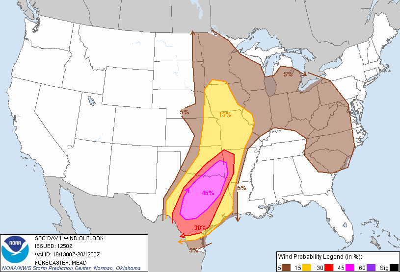
Below is the updated Severe Weather Outlook for today and tonight from the Storm Prediction Center (SPC) in Norman, OK:

Severe storms are forecast within the yellow shaded areas on the image, with the highest ("enhanced") risk within the red shaded areas. The enhanced risk of severe weather includes Ft. Smith, McAlester, the Dallas/Ft. Worth Metroplex, Waco, much of the Texas Hill Country and the Austin-San Antonio corridor along I-35.
Tornadoes, damaging thunderstorm wind gusts and large hail (some very large) are all possible with severe storms in these areas later today and into tonight.
While a tornado is possible with any severe storm in the enhanced (red shaded) risk area today, the highest risk of tornadoes will take place within the yellow shaded areas on the image below, which includes McAlester, Ft. Smith, the Dallas/Ft. Worth Metroplex, Waco, and Northern portions of the Texas Hill Country:

The highest risk of damaging thunderstorm wind gusts will take place within the red (and even more so the lavender) shaded areas on the image below:
...and the threat of large hail will be greatest within the red and lavender shaded areas on this image:

The potential exists for hail in excess of 2 inches in diameter within the black hatched area on the above image.
In addition to the threat of widespread severe weather, widespread, heavy rainfall will also take place today and tonight across much of the same area. This will lead to flash flooding in some areas. The potential exists for as much as 6-8 inches of rain in some areas through tonight:

As mentioned at the top of the post, this is a very complex situation with multiple rounds of thunderstorms and severe weather likely across the above mentioned areas this afternoon and into tonight. Just because one round of thunderstorms and/or severe weather moves through a given location does not mean that the threat will have ended for the day at that location. For this reason, it will be important to keep an eye on the weather throughout the day and into tonight, and listen for the latest watch and/or warning information for your area.
Make sure that you have identified the safest place to seek shelter at home, work or school. Take a few moments this morning to ensure that your severe weather safety kit is stocked and ready to go should you need it.
If you live across especially the Eastern portions of the severe weather outlook area, the threat of severe weather will continue into the night tonight. Make sure that you take steps today to ensure that you have a way to receive severe weather warnings at night.
Please check back to the blog throughout the day for the latest updates as this situation progresses.
If you enjoy reading 'The Original Weather Blog', please be sure to "like" our facebook page!
No comments:
Post a Comment