There will be several areas of active weather next week, with all types of elements involved (from spring-like storms to snow). Of greatest concern at this time is the threat of severe storms, including tornadoes, across portions of the Southern and Central Plains on Monday, the Mississippi Valley on Tuesday, and the Deep South by Wednesday:


The severe storms will also bring widespread rainfall amounts of 1 inch or more to a significant portion of the middle third of the country. This locally heavy rain threat will spread into New England by the end of the week. Meanwhile, the first measurable snow of the season appears likely in a relatively narrow band from northwest Kansas into the Upper Peninsula of Michigan on Tuesday and Wednesday:

Temperature wise, it will generally be cooler than normal in the Great West, with fluctuating temperatures (from warm to cooler to warm again) in the central and eastern two thirds of the nation throughout the week:

Severe Weather Threat South for the First Half of Week:
A relatively strong area of surface low pressure will interact with a very strong middle and upper level weather disturbance and strong jet stream winds to produce a significant threat of severe weather (for this time of year) during the period Monday through Wednesday.
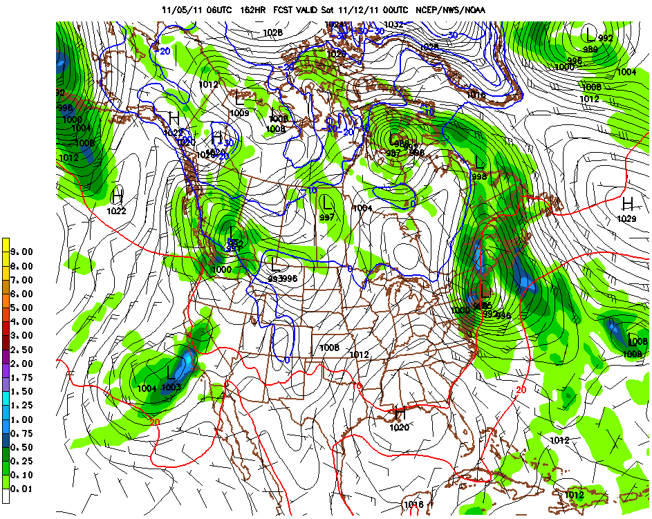
The images below are the latest GFS model surface forecasts valid 6pm CST on Monday, Tuesday and Wednesday:

GFS Surface Map Valid 6pm CST Monday

GFS Surface Map Valid 6pm CST Tuesday

GFS Surface Map Valid 6pm CST Wednesday
I've drawn the applicable fronts on the images. As you can see, a surface cold front and low pressure center will move from the southern and central Plains on Monday into the Mississippi Valley on Tuesday and the Deep South on Wednesday. Meanwhile, in the middle and upper levels of the atmosphere, a band of strong winds and rapidly rising air will overspread the same regions at about the same times, which will result in a threat of severe weather.

GFS Mid-Level Wind Forecast Valid 6pm CST Monday

GFS Mid-Level Wind Forecast Valid 6pm CST Tuesday

GFS Mid-Level Wind Forecast Valid 6pm CST Wednesday
Large hail, damaging winds and some tornadoes are all likely in association with this activity. At this time, it appears that Monday will have the highest severe weather threat, followed by Tuesday, and to a lesser extent on Wednesday. Please see the Significant Weather Trends map at the top of this post for the specific severe weather threat areas by day.
Residents across these areas should remain alert and listen for later updates and forecasts. Review severe weather safety tips and be prepared to seek shelter if threatening weather approaches your area.
The activity will also produce some much needed rain across portions of the middle third of the nation. The GFS models total rainfall accumulation forecast is shown below, which indicates widespread 1 inch or greater rainfall within the blue and red shaded areas on the image:

Unfortunately, other than the Red River areas of North Texas, it does not appear as though widespread significant rains will take place across much of the remainder of the drought stricken Lone Star State. A few folks in central or south Texas may get lucky enough to get underneath an isolated thunderstorm on Monday evening that could produce a locally heavy downpour, but this does not appear to be a widespread event at this time for that part of the region.
As the system progresses further East later in the week, widespread locally heavy rains are forecast across portions of the Northeast, especially New England, by Thursday and into Saturday. This event may end as snow, some of which could be locally heavy, across interior New England late Friday or early Saturday. See the winter weather discussion for more details on this.
Winter Weather Potential for Next Week - First Measurable Plains Snow:
As the system described above moves Eastward, colder air will filter down in the wake of the cold front, changing precipitation from rain to snow in a relatively narrow band from northwest Kansas into Wisconsin and the U.P. of Michigan on Tuesday and Wednesday.
The latest GFS snowfall forecast is suggesting a band of 1-3 inch snow, with locally higher amounts, across this general swath:

As the system progresses into the Northeast toward the weekend, locally heavy snow is indicated across portions of interior New England, especially Vermont and New Hampshire, where the GFS model is currently forecasting 6 inches plus of snow in some spots late Friday into early Saturday:

Stormy Weather for Southern California / Southwest Late Week:
A relatively strong area of low pressure, accompanied by an upper-level weather disturbance, is forecast to invade the Southwest late in the week, bringing windy and wet weather first to Southern California by Friday, then progressing across the Southwest into the weekend.
Below are the latest GFS forecast model images valid 6pm CST on Friday and Saturday:
GFS Surface Forecast Valid 6pm CST Friday

GFS Surface Forecast Valid 6pm CST Saturday
This system will produce locally heavy rainfall across much of the region late in the week:

Please check back to the blog throughout the coming week for updates on these and other developing weather events...
Time Change Reminder:
Finally, just a friendly reminder to make sure that your clocks "Fall Back" on Sunday morning, as Daylight Savings Time ends!
If you enjoy reading 'The Original Weather Blog', please be sure to "like" our facebook page!
No comments:
Post a Comment